PrithviGIS

Indigenous GIS - PrithviGIS - Manya Technologies

PrithviGIS: India’s Indigenous GIS Technology Powering Aatmanirbhar Bharat

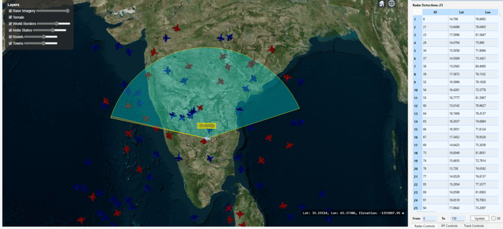
Geospatial intelligence is the silent backbone guiding national decisions, powering defense operations, infrastructure growth, and enterprise transformation. For decades, India has relied on expensive foreign GIS products, often tied with export restrictions, data control concerns, and high licensing fees. But the landscape is changing. A new era of Indigenous GIS innovation is rising in India.At […]

PrithviGIS: India’s Indigenous GIS Technology Powering Aatmanirbhar Bharat Read More »

STK DME track detection - Manya Technologies

Detecting Tracks Using STK DME Component

Introduction In modern defense and aerospace systems, radar-based track detection plays a critical role in situational awareness and threat assessment. Using Analytical Graphics Inc. (AGI) STK DME components, developers can simulate realistic radar sensors, model target motion, and compute detections based on signal-to-noise ratio (SNR), field of view (FOV), and radar cross-section (RCS). This post

Detecting Tracks Using STK DME Component Read More »

Atmanirbhar Bharat - GIS Solution - Manya Technologies

How Indigenous GIS Solutions Can Empower India’s Growth

In today’s world, Geographic Information Systems (GIS) are the backbone of decision-making across defense, urban planning, agriculture, disaster management, and infrastructure development. Traditionally, India has relied heavily on foreign GIS platforms, many of which are powerful but come with limitations such as high licensing costs, dependency on external vendors, and restricted scope for customization. With

How Indigenous GIS Solutions Can Empower India’s Growth Read More »

PrithviGIS

PrithviGIS: India’s Indigenous GIS Solution Empowering Local Development

India is increasingly emphasizing indigenous technology development, encouraging homegrown solutions across sectors. In the geospatial domain, PrithviGIS, developed by Manya Technologies, stands out as a fully indigenous GIS application built on the robust QGIS platform. PrithviGIS offers a wide range of features tailored to India’s local needs, including real-time radar track display, 3D visualization, vector

PrithviGIS: India’s Indigenous GIS Solution Empowering Local Development Read More »

Vector layer symbology - Manya Technologies

Customizing Vector Layers in a Qt Application: Colors, Line Styles, and Visibility

When building a custom GIS application with QGIS API and Qt, one common requirement is to allow users to control how different layers (roads, rivers, boundaries, towns, etc.) are displayed on the map. In this article, we’ll walk through how you can implement a GUI that enables users to: This flexibility ensures that your GIS

Customizing Vector Layers in a Qt Application: Colors, Line Styles, and Visibility Read More »

Scroll to Top