January 2026

DroneMapX-Manya-Technologies

From Raw Drone Images to Actionable Maps: How Modern Drone Mapping Software Transforms Data into Decisions

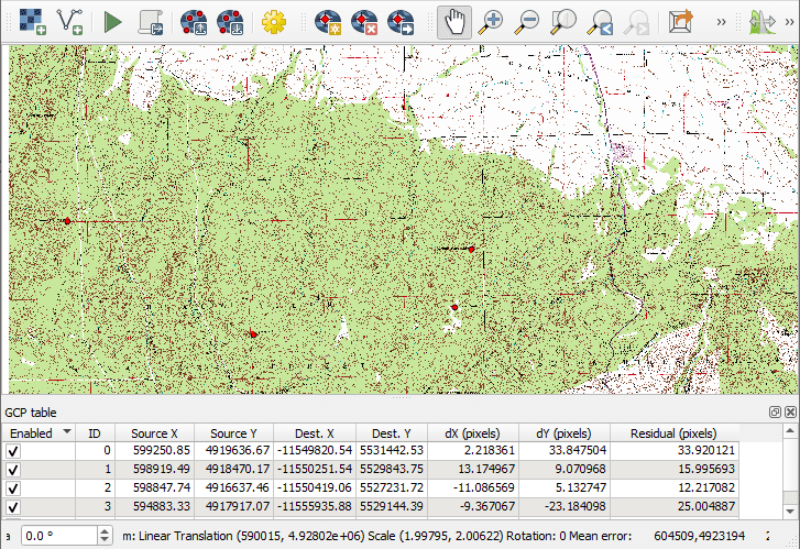
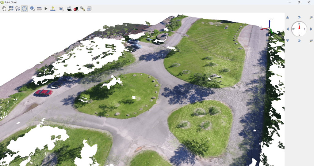
Drone technology has made data capture easier than ever. With a few planned flights, organizations can collect thousands of high-resolution images covering large areas in a very short time. However, raw drone images alone have little value. The real value lies in how this data is processed, analyzed, and converted into actionable geospatial insights. This […]

From Raw Drone Images to Actionable Maps: How Modern Drone Mapping Software Transforms Data into Decisions Read More »

qtquick-qml-Manya Technologies

Why Modern Desktop & Embedded Applications Are Moving from Qt Widgets to QML

Introduction: The Evolution of Qt UI Development Qt has been one of the most trusted frameworks for building cross-platform applications for decades. Traditionally, Qt Widgets dominated desktop application development, powering stable and reliable software across industries such as engineering, defense, GIS, and enterprise systems. However, user expectations have changed. Modern applications demand smooth animations, touch-friendly

Why Modern Desktop & Embedded Applications Are Moving from Qt Widgets to QML Read More »

qtquick-qml-Manya Technologies

Animations in QML: Building Fluid, High-Performance UI for Modern Applications

In today’s software landscape, smooth animations are no longer a luxury—they are an expectation. Whether it’s a real-time dashboard, industrial HMI, map-based visualization, or a mission-critical control panel, animations play a crucial role in usability, clarity, and user confidence. Qt’s QML (Qt Modeling Language) is designed from the ground up to deliver fluid, hardware-accelerated animations

Animations in QML: Building Fluid, High-Performance UI for Modern Applications Read More »

Qt GraphicsScene - Manya Technologies

Real-Time 2D Track Display Using Qt GraphicsScene

Introduction Qt’s Graphics View Framework (QGraphicsView, QGraphicsScene, QGraphicsItem) is widely used for building real-time 2D visualization systems such as radar displays, tactical maps, UAV monitoring dashboards, and simulation tools. In this article, we walk through how a radar-like 2D track display is implemented using Qt GraphicsScene, including: Only key code fragments are shown to explain

Real-Time 2D Track Display Using Qt GraphicsScene Read More »

qtquick-qml-Manya Technologies

Qt Quick & QML: Building Modern, Fluid User Interfaces with Qt

Introduction In today’s software landscape, users expect applications that are fast, visually appealing, touch-friendly, and responsive across devices. Traditional desktop UI frameworks often struggle to meet these expectations without significant effort.This is where Qt Quick and QML shine. Qt Quick is a modern UI framework provided by Qt, and QML (Qt Modeling Language) is its

Qt Quick & QML: Building Modern, Fluid User Interfaces with Qt Read More »

DroneMapX-Manya-Technologies

Why Drone Mapping Software Should Be Vertical-Specific (Not One-Size-Fits-All)

Introduction Most drone mapping software in the market today follows a one-size-fits-all approach. Whether the user is from mining, agriculture, defense, or infrastructure, they are often forced to use the same workflows, same outputs, and same UI — even though their requirements are completely different. As drone adoption increases across industries, it is becoming clear

Why Drone Mapping Software Should Be Vertical-Specific (Not One-Size-Fits-All) Read More »

DroneMapX-Manya-Technologies

OpenDroneMap vs Pix4D vs DroneDeploy vs DroneMapX

A Feature-by-Feature Comparison for Modern Drone Mapping Needs Drone mapping software has evolved far beyond basic orthomosaics. Today, enterprises demand CAD-ready outputs, AI-powered insights, automation, security, and customization. At Manya Technologies, we are developing DroneMapX, an advanced drone mapping software platform aimed at addressing the limitations of both open-source and commercial off-the-shelf tools. DroneMapX is

OpenDroneMap vs Pix4D vs DroneDeploy vs DroneMapX Read More »

Ground Control Points (GCP) - Manya Technologies

Custom GCP Tools for Web-Based Drone Mapping Software

Introduction In modern drone mapping platforms, accuracy is everything. Whether it’s infrastructure surveying, mining, construction, or urban planning, Ground Control Points (GCPs) remain a key factor in achieving reliable, survey-grade results. While many commercial drone mapping solutions offer basic GCP functionality, they often fall short when it comes to scalability, automation, multi-user collaboration, and integration

Custom GCP Tools for Web-Based Drone Mapping Software Read More »

Poincloud - QGIS - Manya Technologies

How to Visualize Point Clouds in 3D Using QGIS

Point clouds have become a foundational data format for modern GIS applications, especially in drone mapping, LiDAR surveys, smart cities, infrastructure planning, mining, and defense. While specialized tools exist for point cloud processing, QGIS now offers powerful native capabilities to visualize and analyze point clouds in 3D—all within an open-source GIS platform. In this blog,

How to Visualize Point Clouds in 3D Using QGIS Read More »

Scroll to Top