In today’s digital era, drone mapping has transformed how we capture, visualize, and analyze our surroundings. By combining drones with advanced mapping and visualization technologies, organizations can generate high-resolution maps, 3D models, and spatial datasets faster and more affordably than ever before.
What is Drone Mapping?
Drone mapping is the process of using unmanned aerial vehicles (UAVs) equipped with cameras or LiDAR sensors to capture aerial images of the Earth’s surface. These images are processed using photogrammetry or point-cloud algorithms to create:
- Orthomosaic maps (georeferenced 2D images)
- Digital elevation models (DEMs)
- 3D terrain and structure models
Drone mapping helps in surveying, construction, agriculture, mining, defense, and GIS applications, enabling precise measurements, progress monitoring, and data-driven decision-making.
Key Use Cases of Drone Mapping
- 🏗️ Construction & Infrastructure Monitoring
Generate accurate site maps, measure stockpiles, and track project progress over time. - 🌾 Agriculture & Forestry
Monitor crop health using NDVI analysis, detect pest-affected zones, and optimize irrigation and fertilization. - ⛏️ Mining & Quarrying
Measure volumes of extracted materials and ensure safety through terrain analysis and slope monitoring. - 🛰️ Environmental & Disaster Management
Assess flood zones, landslides, and deforestation using before-and-after imagery for rapid response planning. - 🧭 Defense & Security
Create high-accuracy terrain maps and 3D situational models for mission planning and surveillance.
How Leaflet, Cesium, and Potree Enhance Drone Mapping
Modern web visualization tools make drone mapping interactive, 3D, and easily shareable.
Here’s how popular open-source frameworks contribute:
🗺️ Leaflet
Leaflet is a lightweight JavaScript library for 2D map visualization. It helps in:
- Displaying orthomosaic maps and vector overlays
- Integrating custom base maps (OpenStreetMap, Mapbox, etc.)
- Adding markers, polygons, and measurement tools
- Building responsive map dashboards for real-time drone data
🌍 CesiumJS
CesiumJS brings 3D globe visualization to drone mapping data. It supports:
- Rendering 3D tiles, terrain, and photogrammetry models
- Simulating drone flight paths and playback
- Displaying real-time GPS or sensor data on a globe
- Integrating with WebSocket servers for live mission tracking
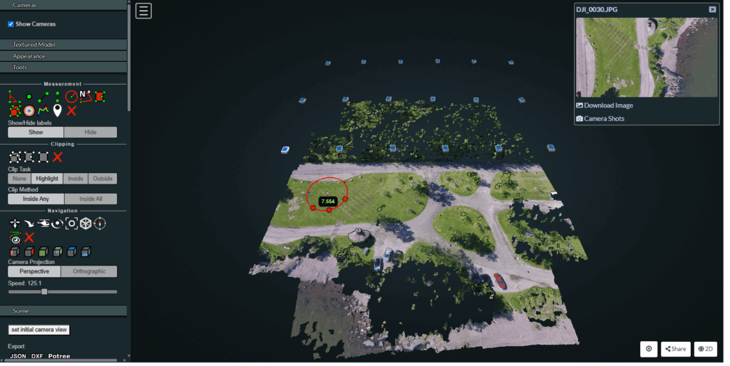
🏔️ Potree
Potree specializes in point cloud visualization in the browser.
It’s perfect for:
- Rendering LiDAR and photogrammetry point clouds
- Inspecting terrain elevation and structural details
- Measuring distances, areas, and heights in 3D
- Combining with Cesium for hybrid globe–point cloud experiences
Together, Leaflet, Cesium, and Potree empower developers to build complete drone mapping platforms — from raw data upload and map generation to interactive 3D visualization.
Functionalities Offered by Drone Mapping Solutions
Modern drone mapping systems can provide:
- Automated flight planning and waypoint control
- Real-time telemetry and video streaming
- 2D/3D map generation and georeferencing
- Measurement and annotation tools
- Integration with PostgreSQL/PostGIS for spatial data management
- Support for web-based analysis
- Multi-user dashboards for project collaboration
Conclusion
Drone mapping is redefining how industries collect and visualize geospatial data. With powerful visualization libraries like Leaflet, CesiumJS, and Potree, data once limited to experts is now accessible to anyone through interactive 3D maps and dashboards.
At Manya Technologies, we specialize in custom GIS and drone mapping solutions — from map visualization to live data integration. Whether you need a real-time drone tracking dashboard, a custom 3D terrain viewer, or a PostGIS-powered analytics system, our team can deliver scalable, robust, and secure solutions tailored to your mission needs.
Let’s collaborate to bring your drone mapping vision to life — powered by innovation, precision, and expertise.